Reviewed by: Adrian Stefanov | Last updated: December 2025
Your Guide to the Best Hikes in Zakopane, Poland
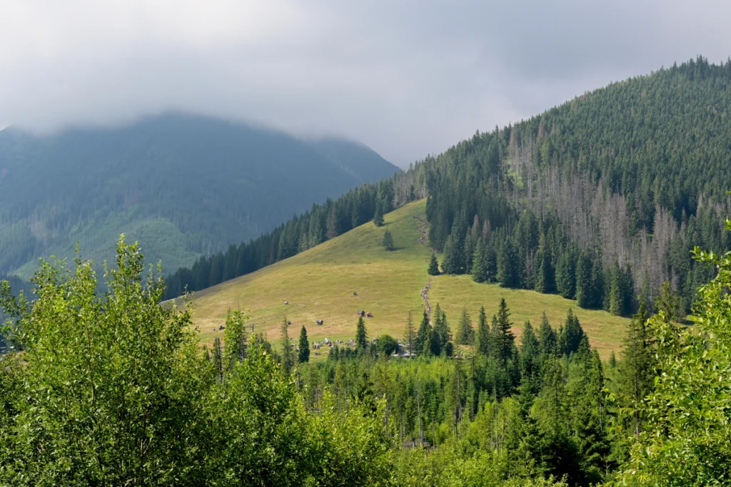
While many think of Zakopane as the winter capital of Poland, the summer season offers well-maintained hiking trails with spectacular views of mountains, valleys, waterfalls, meadows, and streams. Zakopane Poland hiking is the perfect outdoor-focused day trip from Kraków, sitting only 2 hours away. You can choose from tons of different day hikes.
How to Get to Zakopane from Kraków
Before I talk about hiking Tatra mountains in Zakopane, you may find it useful to know how to get here from one of the closest major cities. Zakopane sits about 70 miles (110 km) from Kraków, taking about 2 hours to reach by either car or bus. You can also take the train.
Riding the Bus
The bus is your cheapest option costing anywhere from 45 zł to 65 zł. You can either buy them directly from the bus driver or at one of the bus stations like Bosacka Street 18 or the Kraków MDA Bus Station. They cost 45 zł to 65 zł. You’d want to arrive here 15 minutes before the bus leaves.
Riding the Car
Taking the car to Zakopane is the fastest, and it will take no more than 2 hours, if that. Some people choose this method and go with a private guided tour. Alternatively, you can book a private transfer – a driver will pick you up from the airport and drop you off directly to your accommodation or trail start in Zakopane.
Riding the Train
You can also purchase train tickets from the Kraków Główny train station. If you plan to do this during July or August, keep in mind this is the high season. You will want to book in advance to secure your tickets and enjoy the scenic ride.
Zakopane Poland Hiking: Beginner Trails
Before you can hike in Tatra National Park, you will need to pay an entrance fee of 10 zł. Typically, Zakopane Poland hiking trails for beginners will either be marked in yellow or green, making them ideal for families and novice hikers. Yellow trails are usually shorter, considered as easier, and connect with other trails.
Green trails are typically considered more scenic. Some trails for hiking the Tatra mountains in Zakopane will have multiple color-coded sections like a green trail can suddenly turn into a red trail for a section.
However, even the challenge on beginner trails may vary, so you want to consider things like trail length, elevation, and estimated time. Always check the trail you plan to hike ahead of time to ensure you will be happy with your hike. Let’s take a look at some of the best hikes from Zakopane for beginners.
The best hiking experience is with an expert trekking guide. With a hired guide you’ll see the best hidden routes and learn about the extensive history and secrets of the region.
Nosal
| Starting Point: | Kuźnice |
| Total Hiking Time: | 2 to 2.5 hours |
| Distance: | 3.5 miles (5.6 km) |
| Elevation: | 1206 m |
In Polish, Nosal means nose. They have several noses on the trail and each one offers amazing views. I mention this trail first because they consider it one of the easiest peaks for Zakopane Poland hiking. This is because it is one of the lowest peaks in Zakopane. You can reach the top in 35 to 60 minutes.
It’s marked out as a green trail, but one thing to remember with this one is that it can be a bit steep at the beginning of the trail and the rocks are more slippery due to its popularity. Wear good shoes before going on any hike.
The hike starts from the village of Kuźnice to the south of Zakopane, a 20-minute walk from Wielka Krokiew. You can take in some nice views, and choose to make a loop if you want. It covers 3.5 miles. Many families with children choose this mountain to hike to watch the sunset with it stretching 1,135 ft (1206 meters) above sea level and giving panoramic views.
Tatranská Lesná Trail (Waterfalls to Cold Stream)
| Starting Point: | Near the Tatra Electric Railway Station |
| Total Hiking Time: | 2 hours and 24 minutes |
| Distance: | 6.5 miles (10.4 km) |
| Elevation: | 431m |
Marked as a yellow trail but considered quite easy going along the fast-flowing stream, the starting point is near the Tatra Electric Railway Station. There is no bad weather for this hiking trail. You can go during rainy or sunny weather. Usually, the rainier it is, the more impressive the waterfalls will be.
The total time for this trail takes an average of about 2 hours and 24 minutes and has become popular because of the waterfalls. It lasts for about 6.5 miles (10.4km).
This moderate in difficulty trail is a suitable choice for families and has an elevation of 431 meters. You see some beautiful views along this trail, including the Dlhý vodopád (Long Waterfall).
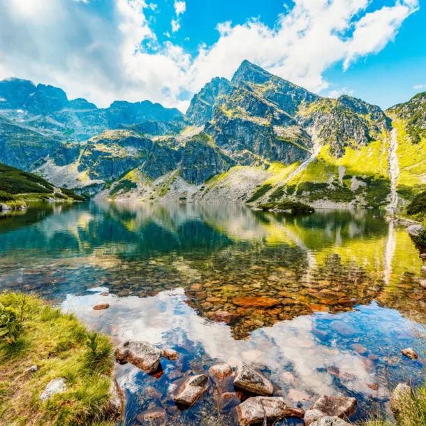
Morskie Oko
| Starting Point: | Palenica Białczańska |
| Total Hiking Time: | 4 to 4.5 hours |
| Distance: | 5 miles (8 km) |
| Elevation: | 1,395m |
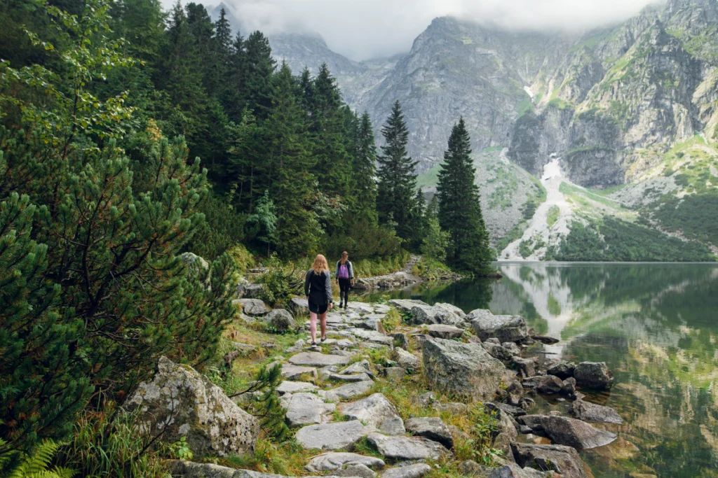
One of the most popular Zakopane Poland hiking opportunities, this one takes you to a glacial lake in the Tatra Mountains, and you begin this trail at Palenica Białczańska, about 15 miles (25 km) from Zakopane. It is highly recommended. In Polish, Morskie Oko means “Eye of the Sea.” It runs for roughly 5 miles (8 km). Going one way will take you 2 to 2.5 hours to get to the foot of the lake.
The hike takes place on an asphalt road, and you can ride in a horse-drawn carriage, but you will miss some of the scenery. If you do decide to go that route, it will cost you 30 zł. One thing to remember here is that if you take a car, you need to reserve a space in advance. The buses here start from the Zakopane bus/train station, but you may want to check the schedule.
This hiking trail has been marked with green and blue trail markers.
One thing to know about this trail is that there are hundreds of other people on this trail, regardless of when you go. If you dislike crowds, you may want to go earlier in the day. You may also see people wandering off the trails and into the trees, climbing up rock steps. This is a shortcut that gets you away from the horse-drawn carriages and the asphalt trail. For those physically able, it can be a good trail to take as a shortcut.
There’s also another glacier lake higher up the mountain called Czarny Staw. This is a more rigorous trail full of boulders and crumbling rock steps. It takes about 40 minutes to get to it and will appear suddenly from out of nowhere.
If you still want to see the lakes but would rather avoid feeling tired out at the end, you might consider a cable car to Kasprowy Wierch.
Rusinowa Polana
| Starting Point: | Wierch Poroniec parking lot |
| Total Hiking Time: | 3.5 to 4 hours |
| Distance: | 6.9 miles (11.1 km) |
| Elevation: | 1,200m |
Known for giving you some of the most beautiful views of the highest peaks, hiking Rusinowa Polana will especially give you incredible views of Łomnica and Gerlac. Others you’ll see include Lodowy Szczyt and Rysy. Even during the summer months, these mountaintops will be covered in snow.
Each Zakopane hike will differ depending on your choice. The main access point from Wierch Poroniec parking lot is a green trail. There is a black trail that descends from Rusinowa Polana to a red trail leading toward Morskie Oko. They also have a blue trail going up to Rusinowa Polana.
This trail has lush green forests, mountain meadows, and diverse rock formations, and it sits 1200 meters above sea level.
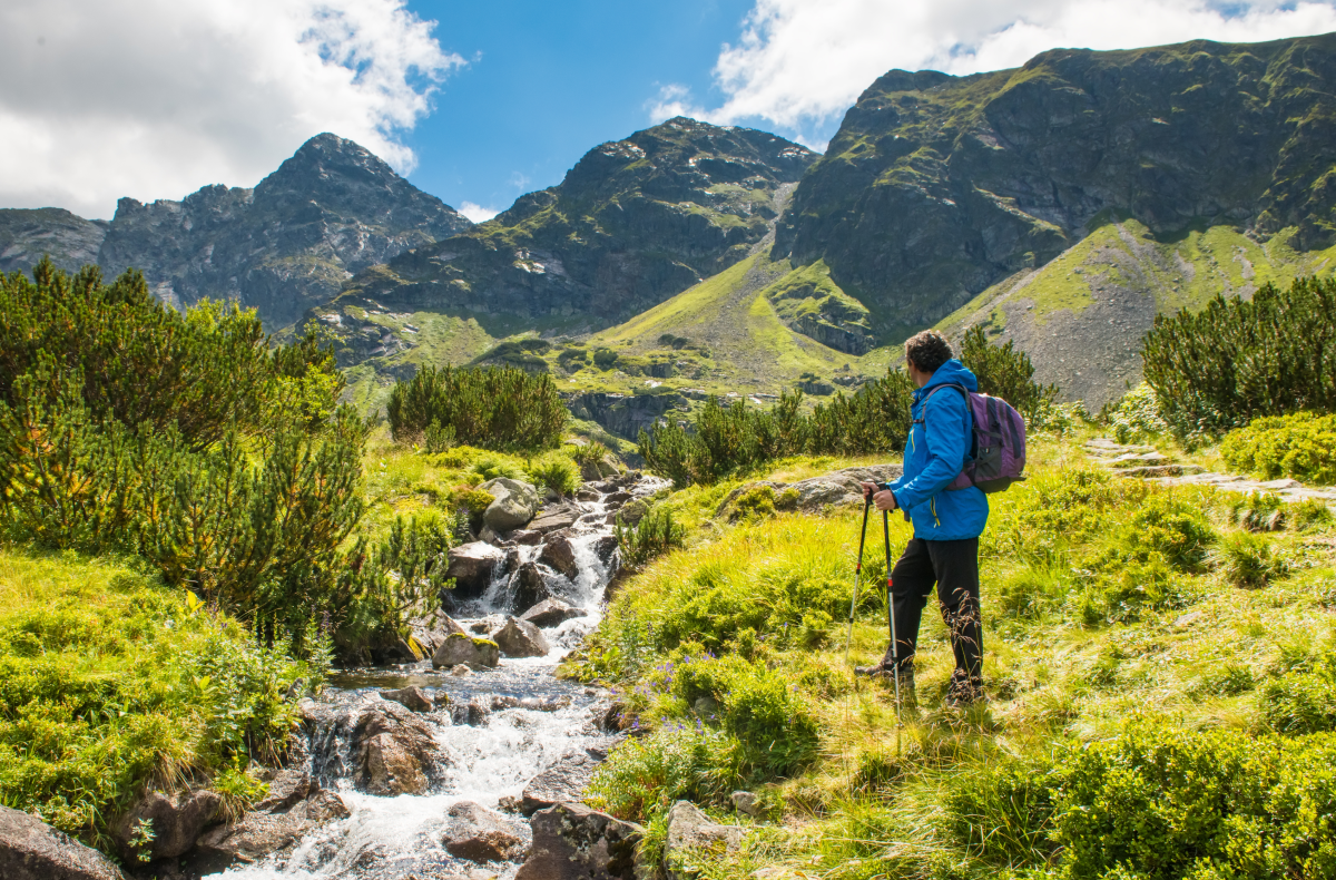
Intermediate Trails
Typically, your intermediate trails for Zakopane hike options will be marked as blue and in some cases, they can also be yellow trails like they can with beginner trails. Intermediate trails will usually have a steeper ascent and more elevation gain.
You may experience rocky or uneven surfaces on the trail. Especially for rocky or uneven terrain, sneakers won’t be enough, and you should wear proper hiking boots. You may want to choose intermediate trails if you’re fairly fit and would like more of a challenge than the beginner trails. Let’s take a look at some of the intermediate trails to choose from.
Strążyska Valley to Sarnia Skała
| Starting Point: | Central Zakopane from Krupowki street |
| Total Hiking Time: | 2 hours |
| Distance: | 4.5 miles (7.2 km) |
| Elevation: | 1,742m |
Covering 4.5 miles (7.2 km), this hike takes you right next to a stream and feels almost dreamlike as it gradually leads you to Polana Strążyska. You will see the popular Siklawica waterfall along the way. The waterfall is a little out of your way, but most find it well worth the extra trip.
As you near the last part of Sarnia Skała, you will see a rock section offering excellent views. Just beware that this one can get slippery especially if you plan to go all the way to the top, but the views will make it worth the trip. You might use sticks in hand to steady yourself.
Walking from Strążyska Valley to Sarnia Skała, this trip will take you about two hours one way, but the whole trip takes around 5 hours to complete. You could also choose the Bialy Valley trail, which is slightly longer.
This trail is full of natural curiosities and rare plants. One of the most popular vantage points here is known as the Sleeping Knight, and you can also see an excellent panorama of Zakopane.
Kościeliska Valley
| Starting Point: | Village of Kiry |
| Total Hiking Time: | 3.5 to 4 hours |
| Distance: | 5.2 miles (8.3 km) |
| Elevation: | 2,090m |
The only real difficult part of hiking Dolina Kościeliska is the steep caves detour part. However, five out of the six caves here are available to tourists.
Outside of that part, the hiking here remains pleasant and flat. Just as a little side note, the Kościeliska Valley is one of the most picturesque valleys in all of the Tatra Mountains. This one also has a big mountain hut toward the end, giving you an impressive view of the Tatras. It’s known as the Ornak Hall Shelter, and it’s a historic building first opened in 1909.
The path is wide and comfortable and climbs gently upward, climbing to 2,090 meters. The path itself will take you on a 5.2-mile (8.3 km) hike. This hike has about a 3 hours and 30 minutes to a 4-hour duration. This trail also has historic memorials along it.
Most of the history here relates to mining, shepherding, and treasure hunting activities that took place from the 16th to 19th centuries. There are, for example, 46 sites with rock carvings, also known as petroglyphs. Some of them date back to as early as 1531 with most archaeologists believing that they came from shepherds, miners, and treasure hunters.
The Five Lakes Valley
| Starting Point: | Palenica Białczańska |
| Total Hiking Time: | 6 to 9 hours |
| Distance: | 7.2 miles (11.6 km) |
| Elevation: | 1,718m |
Taking around 6 to 9 hours, depending on your level of fitness, the Five Lakes Valley goes on for 13.6 miles (22 km). Due to the length of time that it takes to complete, the Five Lakes Valley is considered one of the harder hikes to undertake. However, many consider it one of the best hikes near Zakopane. It sits near the popular Morskie Oko trail.
They do have a little mountain hut along the trail. During this hike you will see the five most popular lakes, which includes the Morskie Oko. Along this trail, you will see things like incredible views, forest trails, valleys, and wildflowers.
The starting point for the Five Lakes Valley trail is at Palenica Bialczanska. It’s about a 30-minute drive from Zakopane, making it one of the best hikes near Zakopane.
Kasprowy Wierch via Myślenickie Turnie
| Starting Point: | Kuźnice |
| Total Hiking Time: | 6 to 8 hours |
| Distance: | 8 miles (13 km) |
| Elevation: | 1,959m |
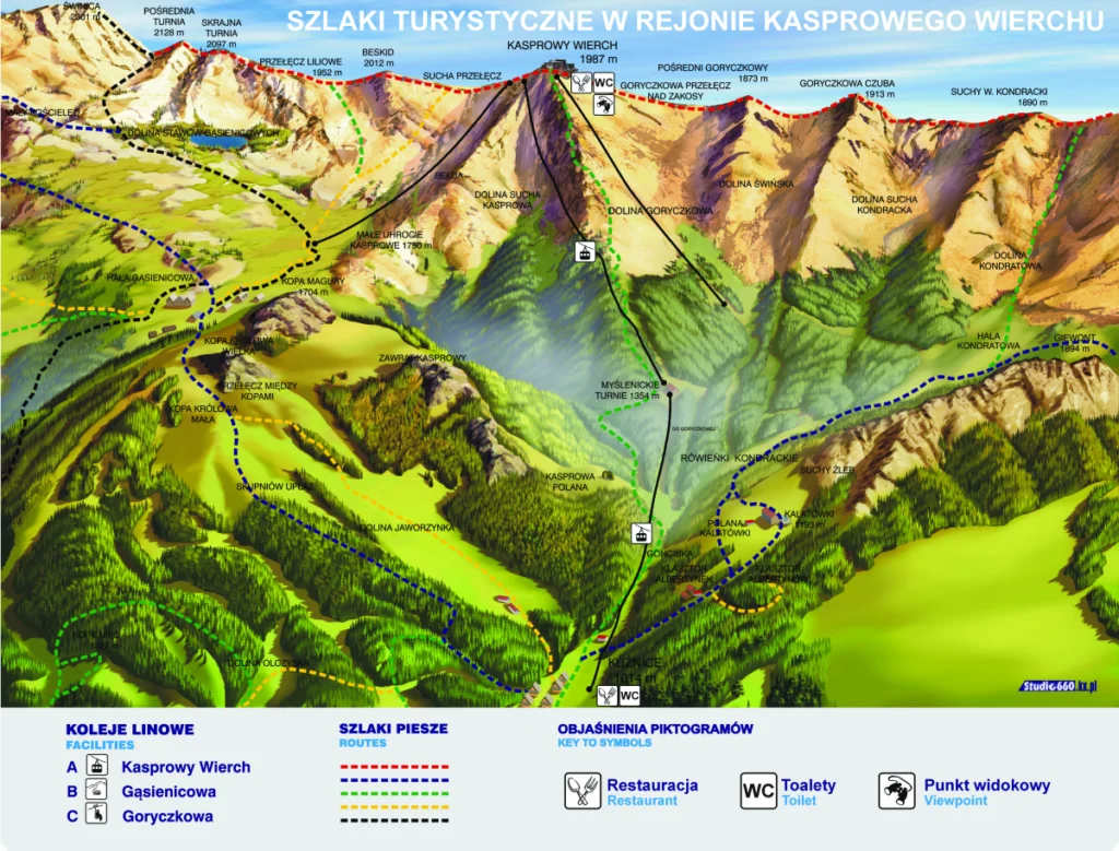
Trail map from Kasprowy Wierch
If you want the simplest way to get to Kasprowy Wierch, the easiest way is to ride the cable car. The ride to the summit takes anywhere from 10 to 15 minutes. Several well-marked trails lead to the summit, and you can also go that way if you would prefer to see the natural scenery.
Just be aware that the path can prove quite demanding, and it will take anywhere from 3 to 4 hours for you to reach the summit. It will require another 2.5 hours to climb back down.
This is another one of the popular tourist destinations, so you can expect more crowds when hiking this one. Once you reach the top, Kasprowy has a restaurant, making it the highest restaurant in Poland at 1,959m. It has a cable car inspired interior with steaks, wild trout, and prawns on the menu. They also have a meteorological observatory.
One of the great things about hiking Kasprowy is that if you suddenly don’t feel well, you can always take the cable car back down. You don’t need any special training ahead of time to hike Kasprowy Wierch. Even families with kids can hike this mountain.
Advanced Trails
For those seeking the most challenge, there are a few hikes from Zakopane that will provide you with the greatest challenge. These are longer hikes, and they have a steeper ascent than others with stiffer elevation gains, rockier terrain, and possibly more technical sections than others. These trails will usually require you to be in better shape than some of the others.
Giewont Peak
| Starting Point: | Kuźnice |
| Total Hiking Time: | 8.5 hours |
| Distance: | 7.5 miles (12 km) |
| Elevation: | 1,894m |
Most consider this trail as intermediate to hard. Many know it for having a challenging ascent, and you will encounter chains up the mountain to help you climb it.
One thing to be aware of with this one is that while it is beautiful, it can be dangerous. Lightning strikes killed several people a few years back due to the metal cross found at the top. In some places, there’s also a risk of an avalanche.
Most of the time with this one, you’ll be climbing up a steepish mountain path through a forest. For those who don’t hike often, you may want to choose something simpler to start to get more acclimated to climbing mountains. This one will push your limits.
As a side note, you could hike Giewont and Kasprowy on the same trip since they’re closer together and both offer about the same amount of challenge. Giewont is best hiked when the weather is dry.
The summit here can be rocky and slippery when wet. It doesn’t have much space for large crowds. As a result, people queue up to hike this mountain. The total time for hiking this is about 8.5 hours.
Rysy
| Starting Point: | Palenica Białczańska |
| Total Hiking Time: | 8 to 10 hours |
| Distance: | 12.5 miles (20 km) |
| Elevation: | 2,499m |
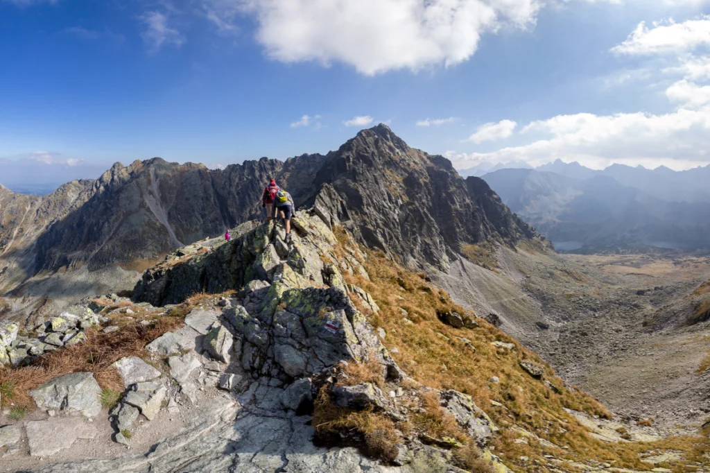
If you plan to hike Mount Rysy, prepare for a challenging but rewarding hike. It is the tallest mountain in Poland, but it’s less dangerous than hiking Giewont. Both of them have about the same amount of challenge.
Much of the challenge from this one comes from the length of time. You can expect the hike to take anywhere from 8 to 10 hours. You will use chains to navigate up the steeper parts of the mountain.
You need to be in decent shape to hike up this one. An early start is recommended because it can be strenuous and the weather unpredictable.
Doing this trail, you will pass by the Morskie Oko Lake, and up until that point, the trail is quite popular, so you would want to leave a little early.
There’s two sides for starting points. You can either start on the Slovak side, or you can start on the Polish side. The Polish side is more challenging with your path being more exposed. However, you may want more of a challenge, and Rysy from the Polish side will give it to you.
Orla Perć
| Starting Point: | Lysa Polana, or Zakopane |
| Total Hiking Time: | 6 to 8 hours |
| Distance: | 8.4 miles (13.6 km) |
| Elevation: | 1,319m |
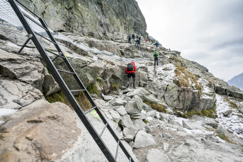
Considered the hardest and most dangerous tourist trail in Poland, Orla Perć is one of the ridge trails that follows a jagged and difficult ridge of mountains in the high Tatra. In Polish, Orla Perć means “Eagle’s Trail.” This path features chains, buckles, ladders, and metal steps to help you as you climb it. It is a steep and rocky terrain.
Over 140 deaths have happened since they first opened this trail in 1901. Most of them have happened with falls in the exposed areas or in bad weather conditions. You need to prepare well for this one before you try it. The trails through Murowaniec to Orla Perć lead through north-exposed gullies.
The swift elevation gain and the extended time hiking add to most of the challenge for this trail. At times, the terrain is exposed perilously so. Still, this mountain is considered the crown jewel for hiking the Polish Tatras. It has a lot of technical difficulty and some stunning vistas. This is one of the best hikes near Zakopane if you’re looking for a good challenge.
They have few exit paths along this trail, so once you commit, you better prepare to go through it all. The Zawrat to Kozi Wierch section is only one way to reduce the congestion, so you can’t turn back once you start.
You can approach the starting point from a few different places, but the most popular are Lysa Polana or Zakopane.
Guided Trekking & Hiking Tours
If you’re interesting in hiking but don’t know where to start, you can hire a local hiking guide who knows the area like the palm of their hand. This way you can focus on the scenery and experience, while letting a pro lead the way. They can personalize routes according to your group’s skill level and make it the best hike you can wish for in Zakopane – from easy family hikes to challenging ‘’via ferratas’’.
Final Thoughts
The Tatra Mountains in Zakopane have many different trails to choose from. Zakopane Poland hiking lets you see everything from rocky peaks, sharp ridges, waterfalls, valleys, and charming Polish lakes. Hiking here is best done from June to September. If you’d prefer to avoid the peak of crowds, you would want to avoid hiking it in July and August since this will be the busiest time. When on the trail, carry an abundance of water and snacks.
You might also like:
50+ Things To Do in Zakopane in Summer

-

“Zakopane Summer Holidays. Explore More, Plan Less.”
Book Accomodation